|
The Grijalva River and the River Sidon
by Joseph L. Allen, Ph. D.
The River Sidon
The most prominent river in the Book of Mormon is the river Sidon. The city of Zarahemla was built along its banks. The river Sidon is mentioned in connection with military movements at the river, baptisms in the river, and bodies floating to the sea in the river. Further, the headwaters of the river served as a point of reference for the north-south boundary line of the Nephites and Lamanites. That is, the headwaters of the river Sidon are in the top of the Cuchumatane Mountains (narrow strip of wilderness). From the headwaters, the river flowed downhill toward Zarahemla. Even today, the headwaters area serves as a dividing line between the country of Guatemala and the state of Chiapas, Mexico. The terms river of Sidon and waters of Sidon are mentioned thirty-seven times in the Book of Mormon.
History
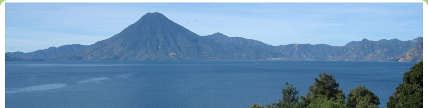
Traditionally, the two leading candidates for the river Sidon in Mesoamerica have been the Usumacinta River, which forms the border between Peten, Guatemala, and Chiapas, Mexico, and the Grijalva River, which originates in the mountains of Guatemala and runs through the big Chiapas valley in Mexico. These two rivers represent the fourth and fifth longest rivers in Mexico. Both the Usumacinta River and the Grijalva River empty into the Gulf of Mexico about thirty miles north of Villahermosa, Tabasco. The Grijalva River, also called the Chiapas or Tabasco River, actually divides the city of Villahermosa. Today, two temples of the Church are located where the Grijalva River flowsone at Tuxtla Gutierrez, Chiapas, and another at Villahermosa, Tabasco.
The name Sidon
The name Sidon was undoubtedly a name given by people of Zarahemla, also referred to as the Mulekites, to the major river that ran through the land of Zarahemla in the new world. The port of Lebanon, which is south of Beirut, is also called Sidon. Sidon is a Hebrew or Semitic word which means fishery or fish waters. We read in the Book of Omni that Mosiah discovered that the people of Zarahemla came out from Jerusalem at the time that Zedekiah king of Judah, was carried away captive into Babylon Omni 1:15. We cannot be sure that the Mulekites departed from the port of Sidon, however, circumstantial evidence suggests that they were transported by the sea faring Phoenicians. The port of Sidon was their major port around 600 BC.
Fish Waters
The term fish waters is also associated with the Grijalva River located in the upper Grijalva valley. These waters are called Xocal Ha in the Maya language, which means fish waters, the same as Sidon in Hebrew. One town located on the upper Grijalva is called Xocaltenango, a combination of two words, one in Maya and the other in Nahuatl, which means place of the fish. Some archaeological evidence hints at the possibility that the ancient Nephites/Mulekites called all the water fish waters, or waters of Sidon, as many tributaries flow into the Grijalva.
The Grijalva River and the River Sidon
Linguistic, archaeological and geographical evidence identifies the River Grijalva that runs through the Chiapas valley as the river Sidon. Plotting the migratory movements of the Nephites from Guatemala to Chiapas is relatively easy because the movements are not only associated with the river Sidon, but with cities of Zarahemla, Sidom, Minon, Manti, Melek, Ammonihah, and Gideon. The wilderness of Hermounts (Tehuantepec) is west and north of Zarahemla. The fortification line referred to as a day and a half journey is also an identifying characteristic of the land of Zarahemla and the River Sidon. Name correlations, elevations, distances and directions are valuable tools in assisting us to identify the River Sidon.
The Usumacinta River is not the river Sidon.
The Usumacinta river was an early proposal by M. Wells Jakemen as a possible candidate for the river Sidon. Other readers of the Book of Mormon still maintain that tradition today. And some tour directors take tours along the Usumacinta River under the guise that the city of Zarahemla was located along its banks. They do so, however, without authorization of archaeological evidence dating from the fifth to second century BC, a strict requirement for any candidate to be the city of Zarahemla. Although many sites located in the Chiapas valley along the Grijalva River dating from 300 BC to AD 250 have been documented, no sites dating to that time period have been documented along the Usumacinta River.
Today, the two most prominent archaeological sites along the Usumacinta are Piedras Negras and Yaxchilan, both of which are Maya Classic sites that were not founded until after AD 250or toward the end of the history recorded in the Book of Mormon. They are located about twenty-five miles from each other, and they are about a hundred miles west of Tikal. They are approachable from Palenque when travelers drive to the Usumacinta River and take a launch upstream. They follow the same political and developmental pattern as the Classic ruins of Palenque, Calakmul, and Copan. A brief analysis of these two sites follows.
Piedras Negras is not a Book of Mormon city.
Excavation work was initiated at Piedras Negras from 1931 to 1939 by the University Museum, University of Pennsylvania. That is more than twenty years prior to the investigative work conducted by the New World Archaeological Foundation at Santa Rosa, which is discussed in chapter 29 of the second edition of Exploring the Lands of the Book of Mormon, The Land of Zarahemla. Beginning in 1997, the site of Piedras Negras became part of a combined Guatemalan and American project led by Hector Escobedo and Stephen Houston, the latter formerly on the faculty of Brigham Young University but not a member of the Church of Jesus Christ.
Like Palenque and Copan, Piedras Negras may have been settled as a small village beginning at AD 250 to AD 300; however, the first ruler, who is simply labeled Ruler A, appears to have ascended to the throne around AD 460. This was 82 years after Spearthrower Owl of Teotihuacan sent his young son Yax Nuun Ayiin to overthrow Tikal and set up a dynasty. And it had been 110 years from the time the Nephites had been exiled from the land of Zarahemla and the land southward. Piedras Negras is the largest site along the Usumacinta River. In its three-hundred-year postBook of Mormon history, Piedras Negras was fraught with many wars. Its collapse also appears to be military in nature, coming directly from its neighbor to the south, Yaxchilan. After the fall of Piedras Negras in the eighth century AD, evidence shows that the Usumacinta continued as a major trade route for another century.
Thus, we see that the site of Piedras Negras did not begin until at least six hundred years after the founding of Santa Rosa, which is located in the Chiapas valley. That is, Piedras Negras did not even have a ruler until after the close of the Book of Mormon. Piedras Negras is not a Book of Mormon city!
No Nephite ever lived at Yaxchilan.
Like its neighbor Piedras Negras, Yaxchilan is a Maya Classic Period site whose dynasty began on July 23, AD 359, more than five hundred years after Mosiah traveled from Nephi to Zarahemla and became king over the land of Zarahemla. Yaxchilan did not exist as a structured city with a ruler until nine years after the Nephites were exiled from the land of Zarahemla. In other words, no Nephite ever lived at Yaxchilan.
Yaxchilan is situated in a horseshoe bend of the Usumacinta River, and although its dynasty describes an origin in the fourth century AD, most of what is seen today is the result of two eighth-century rulers who dominated its landscape.
Just as no serious scholar of historical geography of the Book of Mormon today would consider Palenque, Uxmal, or El Tajin to be a Book of Mormon city, likewise, no reputable student of Mesoamerican history and geography would label Yaxchilan or Piedras Negras a Nephite site. Therefore, we must disqualify the Usumacinta River as a candidate for the river Sidon.
We need only to look at the maps in the Museum of Archaeology at Tuxtla Gutierrezmaps that were designed by the New World Archaeological Foundationto get the picture of the many cities or towns that were located along the Grijalva during the Preclassic Period, in comparison with the Usumacinta, where there were none.
The above comments do not mean that the Usumacinta did not play a role in Nephite history. The 121 BC expedition of Limhi probably followed the Usumacinta River until they came to the land among many waters and subsequently entered into Jaredite/Olmec territory by La Venta, Tabasco. Had they followed the Grijalva River, they would have run into thousands of people and hundreds of towns and cities. And they would have spoken the same language as the Mosiah-Nephites and would have been familiar with the kind of pottery being used by the Mosiah-Nephites in Chiapas, as it is the same kind that was being used at Kaminaljuyu in Guatemala during the same time period.
Not only the presence of cities and pottery but also the name correlations of places like Chiapa de Corzo and the wilderness of Hermounts qualify the Grijalva River to be the river Sidon. Further, the distances and directional and geographical lay of the land regarding the land of Manti, the valley of Gideon, and the day and a halfs fortification line that was intended to stop the Lamanites from going into the land northward, support Grijalva as the river Sidon. Finally, the relationship of the Grijalva River with Izapa, the Isthmus of Tehuantepec, the land southward being hunting grounds of the Jaredites, and the migratory route through the narrow strip of wilderness solidify the Grijalvanot the Usumacintaas the river Sidon.
The Pottery Trail
The most reputable scholar on pottery analysis of the upper Grijalva Valley is Dr. Bruce W. Warren, Archaeologist. He worked nine seasons for the New World Archaeological Foundation with headquarters in Chiapas, Mexico. Warren determined that the pottery from Kaminaljuyu which is often referred to as the Miraflores style appeared in the upper Grijalva between the first and second century BC.
This suggests that if Kaminaljuyu is the city of Nephi, then settlements in the upper Grijalva valley may have been occupied by people from the land of Nephi (Guatemala) during the time of King Mosiah. The distance from Kaminaljuyu (Nephi) to the upper Grijalva (Zarahemla) is approximately 300 miles. The route is ancient Maya route from Guatemala to Chiapas over the massive Cuchumatanes mountain range, or the narrow strip of wilderness which divided the land of Nephi from the land of Zarahemla (Alma 22:27). See Exploring the Lands of the Book of Mormon, second edition for more detail on this migratory route.
Santa Rosa and the city of Zarahemla
Santa Rosa is an archaeological site located in the upper Grijalva Valley that was excavated by the New World Archaeological Foundation prior to being covered over by the Angostura Dam. The New World Archaeological Foundation (NWAF) is sponsored by the Mexican Government and The Church of Jesus Christ of Latter-day Saints. Although, not conclusive, the dating of Santa Rosa falls in the right time period and it manifests culture and pottery styles consistent with people migrating from Guatemala to Chiapas during the late Preclassic period. See Exploring the Lands of the Book of Mormon, second edition for more detail on Santa Rosa.
Zactun and the city Sidom
In the Maya language the word Zac means white or limestone and the word Tun means rock or stone. The word Sidom is an old world name and is also associated with limestone or white stone. A mountain of limestone is located near the Dead Sea and the city of Sodom carries the same meaning as white or limestone. In the Book of Mormon, the city of Sidom is located in the land of Zarahemla. It is where Alma and Amulek located Zeezrom who was sick with fever (Alma 15:3). The name correlation along with its location and dates of occupation makes Zactun a compelling candidate for the city of Sidom. See Exploring the Lands of the Book of Mormon, second edition for more detail on Zactun and Sidom.
Tehuantepec and the wilderness of Hermounts
One of the most dramatic name and directional correlations with the land of Zarahemla and the state of Chiapas, Mexico is the wilderness of Tehuantepec. The Aztec word Tehuantepec literally means wilderness of wild beasts, the same meaning as the wilderness of Hermounts, the wilderness which was infested by wild and ravenous beasts (Alma 2:37). To add creditability to the above correlation, the directional statements in the Book of Mormon are precise relative to the directions from the Grijalva valley to the wilderness of Tehuantepec. They were scattered on the west and on the north until they reached the wilderness, which was called Hermounts (Alma 2:36). And as a side note, the mention of vultures in Alma 2:38 is significant with the same area. See Exploring the Lands of the Book of Mormon, second edition for more detail on the physical and spiritual applications of the Wilderness of Tehuantepec and the Wilderness of Hermounts.
Paredon and the day and a half journey
Any serious discussion on Book of Mormon geography has to take into consideration the day and a half journey fortification line. The purpose of this twelve mile fortification line was to keep in the Lamanites in the land of Nephi in order that they should have nor more possession only in the land of Nephi that they might not overrun the land northward (Alma 22:32-34). The twelve mile (day and a half journey) fortification line extended from the borders of Desolation and Bountiful to the West Sea, or from present day Tonala to the town of Paredon located on the Pacific Ocean. Paredon literally means the big wall. See Exploring the Lands of the Book of Mormon, second edition for more detail on the physical and spiritual applications of a day and half journey.
Chiapas and the East Wilderness
The east wilderness of Zarahemla played a major role in the history and geography of the Book of Mormon. So much so, that one entire chapter in the second edition of Exploring the Lands of the Book of Mormon has been dedicated to the subject. The state of Chiapas, Mexico was originally part of Guatemala and as such was an integral part of the Peten Jungle of Guatemala and the present day country of Belize. The presence of the massive rainforest east of Chiapas is essential to our understanding of the development of Book of Mormon history. Fortified cities, settlements dating to the first century BC, and an east sea all play into the history of the Nephites from 200 BC to AD 400.
© Copyright 2011 by Joseph L. Allen and Book of Mormon Tours and Research Institute, LLC. All rights reserved.